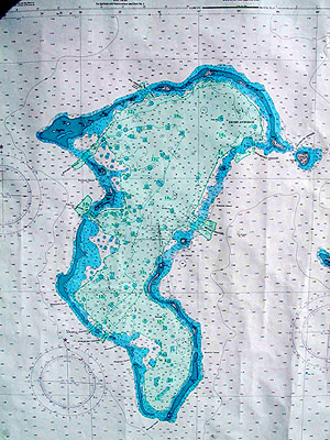
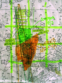
| IV. The 2001 Expedition (In the words of Chip Lambert and Pat Scannon): Research By late morning on 6 April, we were about 30 minutes from giving up our search. Prior to leaving for Ulithi, I (Chip) had spent hundreds of hours going over information on the fate of the USS Mississinewa provided by Mike Mair. While reviewing Mike's (and Bob Fulleman's) web site, I noticed some of the photographs, included in their on-line newsletter, had islands in the background. Mike provided the entire collection of 37 images taken by Sid Harris, as the USS Munsee approached and aided in the rescue efforts for the USS Mississinewa. These photos have been stored in a safety deposit box for most of the past 56 years. Computer-enhancing these photographs, I was able to recognize specific islands on the horizon. More islands were seen on the remaining photographs. With friends, Ron Russell (Zeagle Dive Equipment) and Jorg Dutschke (Alpine Meadows Ski Area), and our experienced group of explorers, Pam Lambert and Pat Scannon, we identified the islands and located them on a chart of Ulithi atoll. By triangulation and measurement of sight lines, we created a "cone of opportunity" within which the ship had to be, effectively reducing the search area from 200 square miles to a more manageable 5 square miles.
As the ninth expedition attempting to locate the ship,
our mission began by meeting with Senator Tony Tareg and Chief Pisente
in Yap and, the next day in Ulithi, with Mr. John Rulmal and Chief Pisente
again, to seek their permission to search for the ship and update them
on our plans. On 31 March, we initiated our search in a 20-foot fiberglass
dive boat using a Humminbird® bottom finder and Garmin® GPS as
our only search equipment. Pat, Pam and I, with three incredibly patient
and professional Ulithians, Faustino Yalomai, Mario Suk and Kenneth Wur,
started scouring our search area within this flat-bottomed Ulithi lagoon. |
|
| Page last modified 17 May 2003 | |
© P. Scannon, 2001
© P. Scannon, 2001